
Thursday, July 26, 2012
Friday, June 29, 2012
Oh, Maharlika!
Oh, Maharlika! I pity the mentally colonized inhabitants of your lush green lands and heavenly blue waters.
You were once;
The real-life Garden of Eden that was coveted by thousands of civilizations that tried to eradicate its existence.
Academy of the wise and fortress of the brave.
Where masters are more loyal to their slaves.
Land of the thousand warriors that shed their own blood for freedom and justice.
The once pure and unalloyed culture that flourished into the peak of uniqueness until their adulteration.
Land of the literates before the hideous conquistadores obliterated your significant history.
Mountains of everlasting gold that the relentless dragons and power hungry bald eagles war against each other just to loot it.
Tower of solid justice and order until the self-centered leaders had brought you down.
Salubrious ancient Maharlikan children that onced played on your grounds now cries for hunger and agony.
Fresh rivers with wonderful fishes are now waters of poison and death.
Temples of society, and huts of prosperity are now ruins filled with debris.
--May the chosen descendants of this once great civilization replenish its legacy again. Someday...
Wednesday, April 4, 2012
Wednesday, February 1, 2012
Kingdom of Maharlika
Legal documentations that prove the existence of Maharlikan Kingdom, and may be used against abusive Oligarchy and other unjust forces that gripped this country and its people to hardships and landlessness.
Lost Kingdom of Maharlika
Tala Estate, the Truth Uncovered
Mohon ng Lupang Maharlika

Lost Kingdom of Maharlika
Tala Estate, the Truth Uncovered
Mohon ng Lupang Maharlika
Tuesday, January 31, 2012
therapsid

The Therapsid that lived about 270 Million years ago were the dominant large terrestrial animals by the later half of the Permian Period.
Having both mammalian and reptilian features, mammals were said be descended from Therapsids.
Monday, January 30, 2012
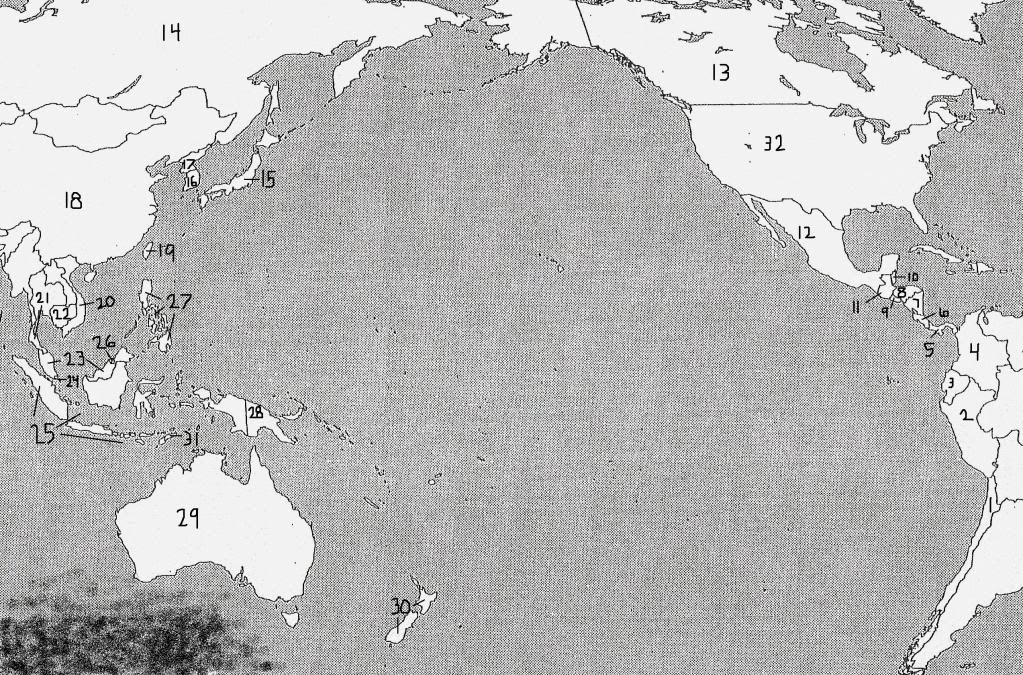
ancient locations in Continent MU / Lemuria
Approximate locations of places and images mentioned in the article "Ancient Indigenous Tribe Narrates Identity of All Tribes in The World Originated From Cibolan in Davao, Philippines"

(click on image for full view)
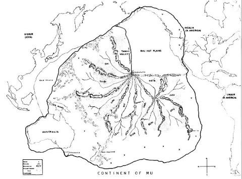
The map is based on possible location of Mu/Lemuria during the Paleozoic Era around 250 Million years ago, and prior to Continental Drift of the land mass Pangaea. Massive Geological changes occurred through the Ages that eventually became the present locations of modern maps, with the archipelago of Maharlika / Philippines that ultimately formed as remnant of ancient Motherland MU / Lemuria approx. 60-50 Million years later through the Geological process of Subduction.
(click on image for full view)
The map is based on possible location of Mu/Lemuria during the Paleozoic Era around 250 Million years ago, and prior to Continental Drift of the land mass Pangaea. Massive Geological changes occurred through the Ages that eventually became the present locations of modern maps, with the archipelago of Maharlika / Philippines that ultimately formed as remnant of ancient Motherland MU / Lemuria approx. 60-50 Million years later through the Geological process of Subduction.
Sunday, January 29, 2012
Personal Researches on Lemurian Timeline
This is a milestone in my personal research. But will consider it as Speculative. there are still probabilities as Many Worlds Theory, Parallel Dimensions, even Synthetic Universe.
Will call it Ric Vil Hori's Research on Lemurian Timeline from Paleozoic Era and up to the Present:
http://www.bibliotecapleyades.net/atlantida_mu/esp_lemuria_3.htm
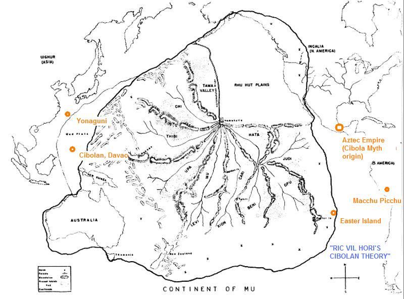
The Map of MU/ Lemuria as shown, manifested the legendary supercontinent in contemporary with the Pangaea supercontinent during the Palaeozoic Era more than 250 million years ago and prior to the Permian-Triassic Extinction Event and the Continental Drift. The early inhabitants of Mu/Lemuria were a hermaphroditic race as narrated by the ancient knowledge of the Indigenous B'laan Tribe of Mindanao Island, Philippines and also by the ancient Greek philosopher Socrates as narrated by Plato. Mammalian species evolved only in the later Cenozoic era.
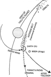
The Permian-Triassic Extinction Event occurred about 250 Million years ago after a complex series of conflicts ensued between Lemurians and another Alien race (said to be Dracos) as narrated by Mindanao's B'laan Tribe and by Socrates, which resulted to genetic splicing of male-female genders, relegation, lowering to denser dimension with the eventual involvement of another force, as narrated by Mindanao's Samal Tribe with its genesis, by ancient Sumerians, and the interplanetary collision as interpreted by Zechariah Sitchin and Immanuel Velikovsky. I highly suggest that the catastrophic formation of the Asteroid Belt may have occurred during this era, which may partly explain the presence of carbonaceous component found in C-Type asteroids manifested during the planet's Carboniferous Period about 360 to 290 million years ago prior to the collision. The catastrophic Extinction event nearly extinguished almost all life during this era, also known as the Great Dying. Surviving Lemurians may have escaped deep underground, with fragments of the Lemurian continent still existing. Other species such as coelacanths, cockroaches, also survived.
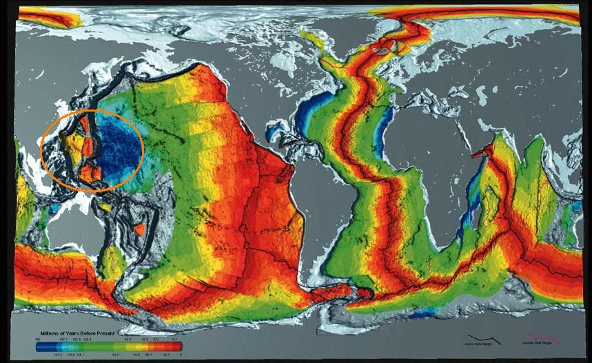
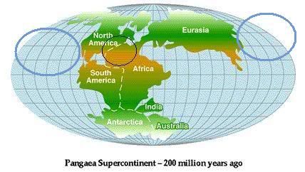
The Continental Drift occurred spanning 225 to 65 million years ago and Pangaea gradually transformed into the present day continents to heal the "wound" that destroyed a large portion of the MU supercontinent caused by the collision, through the wonders of gravity by the "Planet's Core Consciousness" similar to how in microcosmic level spherical shaped water behaves in zero gravity. In this light, the Expanding Earth Theory should be refuted.
New species began appearing, which was further enriched by water from priori-Mars after its front surface was bombarded by fragments from the catastrophic collision, as narrated by Mindanao's Manuvu creation mythology and interpreted by Velikovsky (minus his erroneous timeline). The first mammals appeared (and later evolved into apes) during the Triassic Period about 245 to 208 million years ago and flowers began appearing during the Cretaceous Period about 146 to 65 million years ago.
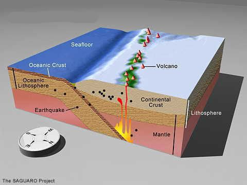
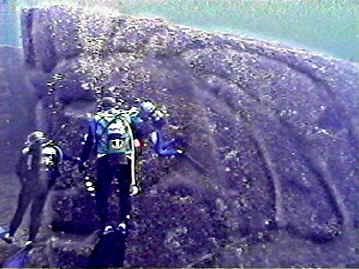
The Cenozoic Era approached about 65 to 1.6 million years ago. The Philippine archipelago began forming through the geological process Subduction (mostly during the Cenozoic -Tertiary/Quaternary Period starting about 65 million years ago). Mindanao Indigenous People's Mythology narrated Human Creation with Addan and Eba who were Created to be MAHARLIKA, meaning Noble, FREE CREATION (Earth Humanity being borne both from Evolution and Creation). Homo sapiens fossilized teeth aged 400,000 years ago were discovered. The remaining fragments of Lemuria sank sometime about 15,000 - 20,000+ years ago in consonance with the galactic wide phenomenon known as the Photon Belt, with sunken remnant of a possible ancient Lemurian city eventually found in Yonaguni, Japan during the 20th Century in the year 1987, also edifices such as the Gunung Padang Pyramid in Indonesia dtaed as much as 20,000 years old or more, Nan Madol in Micronesia, Banaue Rice Terraces in Philippines, the Moai statues of Easter Island, etc.
Tuesday, January 17, 2012
scrutiny
my article, Ancient Indigenous Tribe Narrates Identity of All Tribes in The World Originated From Cibolan in Davao, Philippines, is now under "scary" scrutiny at a science forum, lemme trounce it up ha-ha-ha
http://scienceforums.com/topic/24444-ancient-indigenous-tribe-narrates-identity-of-all-tribes-in-the-world-originated-from-cibolan-in-davao/page__gopid__313352#entry313352
http://scienceforums.com/topic/24444-ancient-indigenous-tribe-narrates-identity-of-all-tribes-in-the-world-originated-from-cibolan-in-davao/page__gopid__313352#entry313352
Sunday, January 8, 2012
Maharlikan Royalty
This is interesting:
ROYAL KINGDOM OF MAHARLIKHAN
The article also confirmed my previous personal research between the ancient ancestors' commercial ties with King Solomon's kingdom some two millennia ago.
ROYAL KINGDOM OF MAHARLIKHAN
The article also confirmed my previous personal research between the ancient ancestors' commercial ties with King Solomon's kingdom some two millennia ago.
Sunday, November 6, 2011
Ancient Indigenous Tribe Narrates Identity of All Tribes in The World Originated From Cibolan in Davao, Philippines Read more: http://www.bukisa.com/
I wrote this article that summarized discussions of my "Ric Vil Hori's Cibolan Theory" :)
Ancient Indigenous Tribe Narrates Identity of All Tribes in The World Originated From Cibolan in Davao, Philippines
Read more: http://www.bukisa.com/articles/590523_ancient-indigenous-tribe-narrate-identity-of-all-tribes-in-the-world-originated-from-cibolan-in-davao-philippines#ixzz1csmCHGSB
Ancient Indigenous Tribe Narrates Identity of All Tribes in The World Originated From Cibolan in Davao, Philippines
Read more: http://www.bukisa.com/articles/590523_ancient-indigenous-tribe-narrate-identity-of-all-tribes-in-the-world-originated-from-cibolan-in-davao-philippines#ixzz1csmCHGSB
Monday, October 31, 2011
Magellan first saw Samal, Davao on March 16,1521??
quotes written by Pigafetta, from book "First Voyage Round the World by Magellan":
1. Samar? Or Samal?
Talikod Island??
These people became very familiar and friendly with us(1), and explained many things to us in their languageand told us the names of the islands which we saw with our eyes before us(2). The island where they dwelt is called Zuluam, and is not large.(3).
1. Samal Tribe?
2. Talikod Island, Davao City area, Davao del Sur, Compostela Valley, Davao Oriental?
3. Other name for Zamal or Samal Island?
1. Talikod Island?
2. Davao Gulf area?
from Samal, Davao they changed course "west and southwest" or 1. Northernmost tip of Mindanao in present day Surigao City?
2. Cluster of islands along Surigao del Norte area, Siargao, Dinagat, Liloan in Leyte, Limasawa?(When viewed on their trip from Samal, Davao, these islands, esp. leyte did look "small" as the expedition viewed these islands by its tip!)
1. from Sri-Vijayan empire?
2. "Lumad Visayan" - mixture of Old Malay, Dravidian Kavi, Sanskrit?
1. Butuan and Caraga?
2. Masao, Butuan?
It seemed that the Spanish expedition of Magellan, lacking in accurate geographical description of the area, tend to identify land masses surrounded by bodies of water as "island," Masao in Butuan seemed to be carved out from river delta that was perhaps misunderstood as "island."
If based on the mainstream historical claim that the first mass was held in Limasawa, Leyte, it's ridiculous for the Raja's of Butuan and Caraga to sail all the way to Limasawa to attend the first mass, unless of course if they chartered a fastcraft ferry for the special occassion, and for Pigafetta and Magellan's crew to visit his kingdom, for both Raja's to meet cordially for gamehunting, there must be regular schedules of fastcraft ferries for the Limasawa - Kingdoms of Butuan and Caraga route since 1521!! LOL
Saturday, the 16th of March, 1521, we arrived at daybreak in sight of a high island, three hundred leagues distant from the before-mentioned Thieves Island, This Isle is called Zamal(1). The next day the general wished to land at another uninhabited island near the first , to be in greater security and to take water, also to repose there a few days.
1. Samar? Or Samal?
The next day the general wished to land at another uninhabited island near the first,
Talikod Island??
These people became very familiar and friendly with us(1), and explained many things to us in their languageand told us the names of the islands which we saw with our eyes before us(2). The island where they dwelt is called Zuluam, and is not large.(3).
1. Samal Tribe?
2. Talikod Island, Davao City area, Davao del Sur, Compostela Valley, Davao Oriental?
3. Other name for Zamal or Samal Island?
The island we were at was named Humunu(1); nevertheless because we found there two springs of very fresh water we called it the Watering place of good signs, and because we found here the first signs of gold. there is much white coral to be found here, and large trees which bear fruit smaller than an almond, and which are like pines. There are also many pine tress both good and bad. In this place there were many circumjacent islands, on which account we named them the Archipelago of St. Lazarus, because we stayed there on the day and feast of St. Lazarus(2).
1. Talikod Island?
2. Davao Gulf area?
That same day (March 25,1521) we took the course between West and Southwest(1) and passed amist four small islands, that is to say, Cenalo, Huinanghar, ibusson and Abarien.(2)
from Samal, Davao they changed course "west and southwest" or 1. Northernmost tip of Mindanao in present day Surigao City?
2. Cluster of islands along Surigao del Norte area, Siargao, Dinagat, Liloan in Leyte, Limasawa?(When viewed on their trip from Samal, Davao, these islands, esp. leyte did look "small" as the expedition viewed these islands by its tip!)
Thursday, the 28th of March, having seen the night before fire upon an island, at the morning we came to anchor at this island; where we saw a small boat which they call Boloto, with eight men inside, which approached the ship of the captain-general. Then a slave of the captain's who was from Sumatra(1), otherwise named Trapobrana, spoke from afar to these people, who understood his talk (2), and came near to the side of the ship, but they withdrew immediately, and would not enter the ship from fear of us.
1. from Sri-Vijayan empire?
2. "Lumad Visayan" - mixture of Old Malay, Dravidian Kavi, Sanskrit?
The island of this king was called Zaluan and Calagan(1), and when these two kings wish to one anotherr they come to this island where we were(2). Of these kings the painted one is called Raia Calambu, and the other one Raia Siani.
1. Butuan and Caraga?
2. Masao, Butuan?
It seemed that the Spanish expedition of Magellan, lacking in accurate geographical description of the area, tend to identify land masses surrounded by bodies of water as "island," Masao in Butuan seemed to be carved out from river delta that was perhaps misunderstood as "island."
If based on the mainstream historical claim that the first mass was held in Limasawa, Leyte, it's ridiculous for the Raja's of Butuan and Caraga to sail all the way to Limasawa to attend the first mass, unless of course if they chartered a fastcraft ferry for the special occassion, and for Pigafetta and Magellan's crew to visit his kingdom, for both Raja's to meet cordially for gamehunting, there must be regular schedules of fastcraft ferries for the Limasawa - Kingdoms of Butuan and Caraga route since 1521!! LOL
Subscribe to:
Comments (Atom)